OpenTripPlanner
A multimodal router for OpenStreetMap
David Turner
OpenPlans
Outline
- Questions
- Overview
- Development
- OSM features
- Common problems
- Future directions

Overview
- Multimodal
- Flexible
- Accessible
- Extensible
- Free and Open Source
Analyst

Features
- JSON and XML APIs
- Routing backend
- Analysis tools (travel time rasters)
Data sources
- GTFS
- OSM (or shapefiles)
- NED
Development
- Summer 2009: Development kicks off
- Funding from TriMet
- OpenPlans leads development
- Volunteer developers from around the world
- Dozens of deployments across roughly 100 regions
- Back-end for several mobile transit apps
- Soon: all North American metros with transit data
OSM
- OTP supports numerous OSM features
- Improving the map can improve routing
- Comparing routing results against local knowledge can improve the map
Names and narrative
- Street names come from:
- name= (from ways and relations; best bet)
- highway=, bridge=, tunnel=, service= (when street names are missing)
- junction=roundabout (so that we can tell people to take the 3rd right)
- note= or notes=
- surface=unpaved, compacted, ground, dirt, earth, grass, mud (we give alerts)
Routeable ways
- highway=* (except construction, proposed, conveyor, raceway)
- railway=platform or public_transit=platform
Exceptions:
- access=no or license
- access=destination, private, customers, delivery, forestry, agricultural (start/end trip only)
Per-mode permissions
- bicycle=yes, foot=yes, motorcar=no (also foot/bicycle=designated)
- cycleway=dismount (OTP always allows dismounting, but this forces it)
- oneway=true or -1
- oneway:bicycle=-1 and bicycle:backwards, cycleway=opposite, cycleway:left=opposite or cycleway:right = opposite
- highway=crossing or footway=crossing (does not circumvent turn restrictions)
Per-mode permissions, cont'd
- Pedestrian-only unless bicycle=yes
- highway=steps, platform
- railway=platform, public_transit=platform
- footway=sidewalk;highway=footway
-
Pedestrian and bicycle (unless otherwise specified)
- highway=cycleway, path, pedestrian, footway, bridleway
Bike safety Model
- Safety is modeled as a length multiplier
- Values come from TriMet's interns
Bike safety Tags
- OTP's bike safety model takes into account
- highway=
- cycleway=
- surface=
- bicycle=designated and RLIS/CCGIS:bicycle=caution_area
- slope (from NED & ele tags)
Bike safety model snippet
setProperties(props, "highway=residential_link;cycleway=opposite", StreetTraversalPermission.ALL, 0.98, 0.98);setProperties(props, "highway=tertiary;cycleway=opposite", StreetTraversalPermission.ALL, 1, 1);
setProperties(props, "highway=tertiary_link;cycleway=opposite", StreetTraversalPermission.ALL, 1, 1);
setProperties(props, "highway=secondary;cycleway=opposite", StreetTraversalPermission.ALL, 1.5, 1.71);
setProperties(props, "highway=secondary_link;cycleway=opposite", StreetTraversalPermission.ALL, 1.5, 1.71);
setProperties(props, "highway=primary;cycleway=opposite", StreetTraversalPermission.ALL, 2.06, 2.99);
setProperties(props, "highway=primary_link;cycleway=opposite", StreetTraversalPermission.ALL, 2.06, 2.99);
Bike safety model snippet 2
setProperties(props, "RLIS:bicycle=caution_area", StreetTraversalPermission.ALL, 1.45, 1.45, true);setProperties(props, "RLIS:bicycle:right=caution_area", StreetTraversalPermission.ALL, 1.45, 1.0, true);
setProperties(props, "RLIS:bicycle:left=caution_area", StreetTraversalPermission.ALL, 1.0, 1.45, true);
setProperties(props, "CCGIS:bicycle=caution_area", StreetTraversalPermission.ALL, 1.45, 1.45, true);
setProperties(props, "CCGIS:bicycle:right=caution_area", StreetTraversalPermission.ALL, 1.45, 1.0, true);
setProperties(props, "CCGIS:bicycle:left=caution_area", StreetTraversalPermission.ALL, 1.0, 1.45, true);
Bike Safety, conclusion
- > 400 lines
- Room for improvement: lit=yes
Turn Restrictions
- relation type=restriction
- except=motorcar, bicycle
- restriction=no_*_turn or only_*_turn
- Coming soon: hour_on, hour_off, day_on, day_off
Turn Restrictions: example
Relation: 1694152

| Tags: | type = restriction |
| restriction = only_straight_on | |
| Members: | Way West Burnside Street (118756155) as to |
| Node 567256143 as via | |
| Way West Burnside Street (128309208) as from |
Elevation
- Most elevation data from National Elevation Dataset (NED) rasters
- NED is mapped to a weird datum
- NED is ground-level, not bridge-level
- bridge=yes or tunnel=yes: fill in elevation from connected nodes
- OSM ele tags fill in gaps (e.g. bridges)
- Demo
Wheelchair Accessibility
- Wheelchair accessibility is a major priority for OTP
- highway=stairs
- wheelchair=no
- wheelchair:description
Elevators
- highway=elevator
- level=#
- layer=#
- relation type=level_map
- levels=
Areas
- e.g. Pioneer Square
- area=yes
- relation type=multipolygon, area=yes
- Uses visibility graph
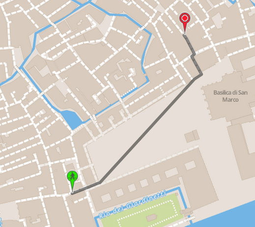
Areas: Piazza San Marco
Areas: Martinez, CA

Common Problems
- Some areas have weird cracks or crannies, causing the area builder to fail
- Bridge ends often fail to match up to NED data, leading to dips at the start/end of bridges
- The sorts of errors found by KeepRight -- almost-junctions, floating islands, impossible angles, missing turn restrictions, etc
- The usual issues that any router has -- streets not matching up with reality
- OSM-GTFS connectivity issues around train stations: partially mapped stations can lead to floating islands
- Micro-mapped buildings can lead to strange snapping
Future directions
- Incorporate traffic signalization (stop lights, stop signs) and other node safety features into pedestrian routing.
- Car routing: maxspeed:motorcar, maxspeed:forward, toll or toll:motorcar
- Ferries from OSM (when there is sufficient data; need frequency, duration)
Questions
?
Epilogue
